Yonge + St. Clair
January 3, 2017
The History of St. Clair Avenue
St. Clair Avenue has played a long and important role in Toronto’s history and today the Yonge + St. Clair blog explores this amazing history.

The History of St. Clair
The first settlement on St. Clair was right at Yonge Street, where the Heath family bought land in 1837, with settlements rapidly growing westward from there. As the street grew in prominence, the British would eventually lay out St. Clair as the third concession road in Toronto, two kilometers north of Bloor, and four away from Queen Street. Over the next 70 years, the municipalities of West Toronto, Earlscourt, Dovercourt, and Oakwood were established along St. Clair Avenue.
These municipalities were eventually annexed by the City of Toronto between 1908 and 1911 and became entirely managed by the city. It was at this time that the city built the 512 streetcar line from Yonge Street to Caledonia Road, allowing St. Clair to become a vital crosstown line for the city. The introduction of the 512 streetcar allowed St. Clair to better serve the city’s rush hour traffic, and eventually allowed the avenue to become a part of provincial highway 5A in 1941. By 1952, the surrounding infrastructure developed enough that it no longer needed to be a part of the provincial road system.
Much of the development from this era survives, with St. Clair experiencing little development since the 1950s, especially relative to the rest of Toronto.

The 512 Streetcar Line
On the early morning of August 25th, 1913, the 512 St. Clair streetcar made its maiden voyage to very little fanfare. In fact, there was a bit of controversy behind its implementation with locals not agreeing with the decision to give the streetcar its own right-of-way lane. Controversy or not, St. Clair Avenue has the distinction of being one of the first five laneways in Toronto to become equipped with a streetcar, and over time it played a vital role in the development of the city’s midtown. In 1909, four years before the 512’s opening, only 5 people lived on St. Clair east of Dufferin. Residents at that time had to trek to Davenport Road to access the nearest transit line.
As Vintage Home Boutique wrote, the fare to ride the 512 streetcar cost only two cents and ran ‘every 6 minutes during the day and every 4 minutes during rush hour.’ The dedicated lane for the 512 only lasted until 1928, but was reimplemented in 2005, reopening earlier this year.
The laying of the 512 streetcar line marked Toronto’s northward growth and not only helped cement the impact of the avenue for the city, but elevated the lives of the residents along St. Clair.
The Namesake of St. Clair
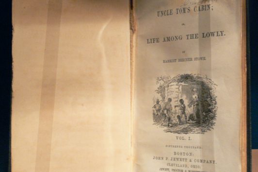
As for the origin of the St. Clair name, many assume that it is derived from the Roman Catholic Saint Clare, but this is untrue. The St. Clair name is literary in origin, derived from the character Augustine St. Clare from the 1852 novel Uncle Tom’s Cabin. The Grainger family, who rented a farm near present day Avenue Road and St. Clair, had viewed a theatrical production of the novel. One of the Grainger boys, Albert, decided to use ‘Clair’ as his middle name as he wasn’t given a middle name at birth. For fun, Albert painted the misspelt name on a sign and nailed it to a tree on his family farm. The sign was discovered some time after the Graingers’ death in 1872, and was subsequently adopted as the name for the street.
Yonge + St. Clair thanks the Grainger boys for their part in our history.